Bobcats and Cottonmouth to south of Eagle nest

Bobcats and Cottonmouth to south of Eagle nest

Administrator
|
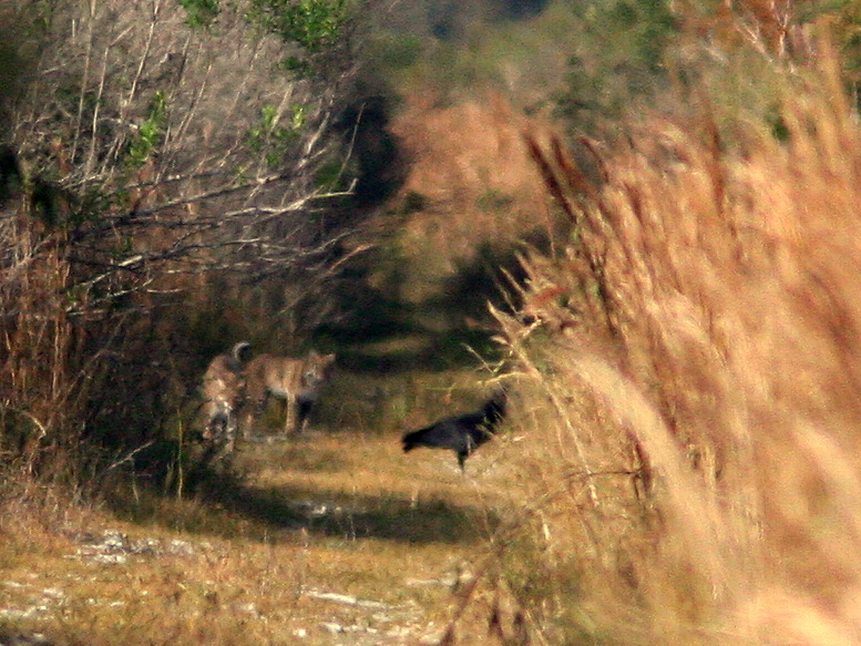
Yesterday I photographed two Bobcats as two Black Vultures stood by in hopes of getting some left-overs from their prey. See the full story HERE in my latest Blog I also had a close encounter with a Cottonmouth! All this happened in the wetlands just about a mile southeast of the eagle nest.
Ken Schneider
Web site: http://rosyfinch.com Blog: http://rosy-finch.blogspot.com Photos: <http://flickr.com/photos/rosyfinch> |
|
|
Wow! I would have LOVED to have captured that image. I have never seen a bobcat in the wild.
Thank you for sharing! |
|
|
In reply to this post by NewMexiKen
Looking at your aerial photo, do you enter what you call the West Miramar Wetlands at the end of miramar pkwy in the sunset lakes subdivision? i didn't know that was all back there
|
|
Administrator
|
Yes, there seems to be no other means of entry to the "West Miramar ESL" other than via the unpaved west end of Miramar Parkway. The problem is that the dead end of the road is posted and Miramar prohibits on-street parking. Police patrol inside the area at times, but have (so far) been friendly to pedestrians. Some people park along the fence, being careful not to block the gate, but I'm not sure it is legal. I simply walk in legally on Sunset Lakes HOA property, as I am a resident. I've never tried to access the area by way of the eastern end of Pembroke Road, off US-27, but this may only lead to the west side of the Harbour Lakes ESL-- there seems to be no trail to the east from there. I've only seen fishermen use that area. Access from the north on 198th Avenue is blocked by water, a fence and private property.
A couple of planned changes will impact the area, depending upon availability of public funds. The first will be completion of the extension of Miramar Parkway, which will curve north and become 196th Ave, joining up with Pembroke Road and US-27 (but probably not directly north to join Pines Boulevard). This will change access to the ESLs, for better or for worse. It will also turn Miramar Parkway into another main artery to connect the area west of I-75 with US-27. The other is a CERP (Comprehensive Everglades Restoration Program) project to create two new Broward County Water Conservaion Area impoundments (C-11 and C-9) along US-27. C-11, in western Weston is scheduled to be completed first. C-9 will include the SFWMD lands south of the eagle nest, west of Miramar and possibly much or all of the Sunset Lakes and Harbour Lakes ESL's. Dikes would be increased in height to about 12 feet, and the entire area could become a huge lake with up to 4 or 6 feet of water, functioning as a STA to block seepage to the east and help in flood control, as well as settle out phosphates to purify the water for release into the Everglades sheet flow. Of course, the entire character of the area would thereby be changed drastically. I'm not sure of the exact boundaries of C-9. A SFWMD representative will provide the Pembroke Pines Bald Eagle Sanctuary Steering Committee with a briefing at our next meeting at the end of this month. Minutes of the meetings are available at links on the Eagle Nest Watch main page.
Ken Schneider
Web site: http://rosyfinch.com Blog: http://rosy-finch.blogspot.com Photos: <http://flickr.com/photos/rosyfinch> |
|
Administrator
|
I received this e-mail that raises an interesting question. Please recognize the limits of my understanding of the CERP projects. If any reader can correct or elaborate upon my comments, please do.
Ken Hi Ken, I wanted to comment on your response about access to sunset lakes ESL. I too am a sunset lake resident. I bought a beautiful home overlooking the everglades preserve on 195th terrace when I moved down from DC last year.. Now I was told by the county that there would be no further development near or around me. I'm not sure I wouldn't mind seeing a road push thru the dead end of miramar parkway to connect to 27 (since my office is in Doral and I fly out of MIA constantly); I'm more concerned about this CERP you mention. I was told that I didn't even need flood insurance. You description, should this go through, sounds like I may have water in my house whether I like it or not. Might you have a web link to updated information on this project. I guess I shouldn't put off getting flood insurance even though my property was deemed high enough. thanks, L-- Hi, L-- As I understand it, the main purpose of CERP is to restore sheet flow of clean fresh water to the historic Everglades, at least to the 1/3 to 1/2 of what is left of the "River of Grass." To do this, many of the ditches and canals that were dug in the middle of the last century to "reclaim" the land for agriculture and development must now be undone. Aside from the adverse aesthetic and ecological effects, this drainage system also wasted rainwater into the ocean rather than allowing it to recharge our aquifer, which is the source of our drinking water. To control the water flow, CERP is constructing a system of water preservation reservoirs or impoundments. These trap rain water and release it more predictably, actually reducing the threat of flooding in developed land to the east, such as Sunset Lakes. The planned local C-11 and C-9 impoundments will require levees that are higher than those that you can see along the west side of the 196th Avenue canal (An example of the higher levees are those along the west side of US-27). They will actually serve as part of the system of Stormwater Treatment Areas (STAs) that remove excess phosphorus from the water before releasing it to the sheet flow. The phosphorus comes mostly from fertilizer used in agriculture, especially sugar cane cultivation, as well as mining. Healthy Everglades water is normally very poor in nutrients, and the phosphorus helps cattails and exotic plants to replace the Sawgrass. The native plants evolved in the nutrient-poor ecosystem, and are unable to compete with the well-fed invaders. So, the bottom line is that our flood threat would actually be diminished by CERP activities. However, we also did not need flood insurance, but bought it anyway. We almost needed it during Hurricane Wilma, when palm fronds accumulated in the streets at the height of the storm, and blocked the storm drainage right in front of our house. The water rose almost to our front door before a neighbor ran out with a rake and unblocked the grating. Having both flood and general homeowners policies avoids the finger-pointing when there is a question about which policy covers water damage of any kind. Since we are above the flood zone, it is not all that expensive for the peace of mind that flood coverage provides. Besides, though our lake did not rise that much with Wilma, a 100 year flood could hit any time. I hope that the SFWMD presentation will provide us with a more specific timeline and also a more exact understanding of the topography of the C-11 and C-9 projects. If you Google "CERP" and "SFWMD" you will obtain lots of information, but so far I have not found a clear map of the boundaries of the planned local impoundments. Start here: http://www.evergladesplan.org/index.aspx Since these activities will impact the foraging areas of the local eagles, the Steering Committee has a vital interest in them, and we will keep everyone informed as information is obtained, hopefully in plain English-- I have toruble cutting through the plethora of acronyms. I still don't know what the "C" stands for in the numbering system for the water conservation projects! Ken
Ken Schneider
Web site: http://rosyfinch.com Blog: http://rosy-finch.blogspot.com Photos: <http://flickr.com/photos/rosyfinch> |
|
|
In reply to this post by NewMexiKen
Wow Ken! Bobcats abound! (But I didn't know they were so close!) I saw one yesterday at STA 5.....but it was really running and leaping. (pretty close to me actually) I was too surprised to even lift my camera!
I always assumed the C stood for canal.....but never really thought about it...duh me! |
«
Return to Local Habitat and Inhabitants-- Photos and reports
|
1 view|%1 views
| Free forum by Nabble | Edit this page |